Management Information Systems (MIS) The City of Winfield Management Information Systems Department is responsible for the development, operation, and maintenance of all City information systems and technology related hardware and software.
Geographic Information Systems (GIS) Geographic Information Systems (GIS) works to facilitate, enhance, support, and enable the 'decision making processes' within the City of Winfield infrastructure through the use of electronic geographic based data.
Contact Jerred Schmidt Director of Information Systems
Ph: (620) 221-5526 Fx: (620) 221-5594 More Information on MIS/GIS Click v to expand
Mapping & GIS
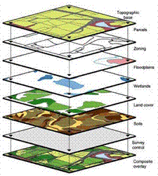
Mapping and GIS, a segment of the Information Systems department provides computer-based mapping services to City departments, the citizens of Winfield, design professionals, contractors, and developers. The Division maintains large computer databases and applications to provide maps, geographic analysis, aerial images, and geospatial data reporting capabilities in manual and electronic format. Capable of providing city infrastructure assets-streets, electric, natural gas, water, sewer- Mapping and GIS focuses on property parcel information, addressing, zoning, land use, and other community development data, as well as, parks and open spaces. GPS technology and aerial photo-images are used to accurately locate and map features across the landscape. The GIS Division utilizes ESRI's ArcGIS Enterprise suite of software and maintains layers and data.
Frequently requested Winfield GIS maps can be accessed easily below:


 the citizens of Winfield, design professionals, contractors, and developers. The Division maintains large computer databases and applications to provide maps, geographic analysis, aerial images, and geospatial data reporting capabilities in manual and electronic format. Capable of providing city infrastructure assets-streets, electric, natural gas, water, sewer- Mapping and GIS focuses on property parcel information, addressing, zoning, land use, and other community development data, as well as, parks and open spaces. GPS technology and aerial photo-images are used to accurately locate and map features across the landscape. The GIS Division utilizes ESRI's ArcGIS Enterprise suite of software and maintains layers and data.